Authors: Colin Price, Marita Bradshaw and Mike Smith
Extract from National Rock Garden Newsletter No. 19, May 2020
About the Authors
Colin Price was an exploration geologist for 20 years before becoming an Earth and Environmental Science (EES) teacher at Daramalan College in Canberra. Colin has twice been a finalist in the teacher’s category of BHP Foundation Science and Engineering Awards and received a Highly Commended award in the 2019 Prime Minister’s Prizes for Science, for promoting open-ended learning and for his work in EES education. Marita and Mike make up the Education Committee of the Steering Committee of the National Rock Garden (NRG).
The NRG Education Committee is building relationships with geoscience educators to gain advice in regard to specific rocks which might be considered for inclusion in the display at the NRG. These specimens would be chosen based on their value as educational material. The Committee recently met with Colin Price to gain some appreciation of his teaching methods.
Daramalan College in Canberra provides Earth and Environmental Science (EES) students with direct exposure to the challenges of geological analysis by conducting practical field excursions. One excursion takes Year 11 students to a field northwest of Yass where there is a prominent exposure of a volcanic ash flow, a rock called an ignimbrite, which is overlain by a sequence of various sedimentary rocks. This field area was suggested by Garry Knight, a former EES teacher at Daramalan, who was shown the area back in the 1970’s when he was a geology student at ANU. Incidentally, Garry was in the same geology class as NRG Chair, Brad Pillans (see our photo on the last page).
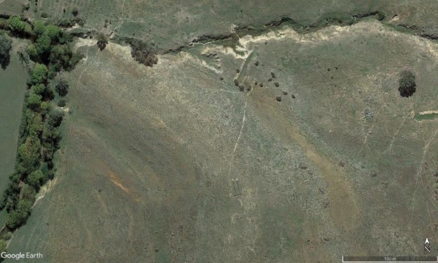
All of the units dip at about 20 degrees to the west, enabling students to walk across the rocks and so recognise and describe the layered sequence of sandstone, siltstone and limestone. The exposures are in creek beds and on gently undulating sheep pasture sparsely covered by grass and thistles, allowing convenient inspection of the various units (Figure 1). The youngest unit, in the southwestern corner of the area, is a shale unit and does not outcrop.

Before the excursion, the class is provided with a 1:50 000 scale regional geological map (Colquhoun & Cameron, 2013) and relevant sections of a report by NSW Government geologists (Thomas & Pogson, 2012). The students are given a notebook, clipboard, 1:2 000 scale Google Earth image, Suunto compass/clinometer and protractor for a day of practical field work. They also draw 5 metre spaced contour lines onto their image by using the elevation tool on Google Earth.
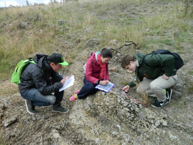
During the excursion, students are first taught how to locate themselves on the image, describe the rocks and fossils in each outcrop in their notebooks, and build up a fact map of the geology. This includes taking dip and strike readings and plotting these on the image (Figure 2). They are encouraged to describe at least two outcrops in each unit and then use the textures and trends on the image to turn their fact map into an interpreted geological map. The task that best shows their level of understanding is the conversion of the elevation contours, rock types, rock unit boundaries and dips and strikes into a cross-section sketch of the layers, from which they measure the true thickness of each unit and produce a stratigraphic column.

More importantly, the students interpret the depositional environment for each rock unit and the progressive changes in that environment from the older rocks to the younger rocks. The sequence records a rise in relative sea level (marine transgression), from volcanics on land to shallow water with coral patches, and then deep water as the shales were deposited by settling of fine particles.
The shallow marine sandstones are mostly massive in texture and the result of mass flows of weathered volcanic material eroded from the land, periodically swamping the coral reefs and shallow sea bottoms. Graded bedding can be found in just one outcrop of interbedded siltstone and sandstone, but these subtle changes in grain size enable the observer to decide that the dipping rocks are the right way up.
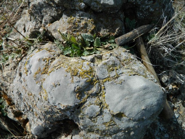
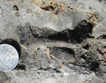
Students are most interested in the fossils in the limestone units. The most common fossils are tabulate and rugose corals, crinoid ossicles and stromatoporoids (Figure 3). A more careful search results in fossils of gastropods, brachiopods, bryozoans, fragments of trilobites and plates from the armoured skulls of placoderm fish (Figure 4). These fossils build up a picture of what life was like in the shallow tropical seas.

These rocks are Silurian in age and were deposited along the complex edge of the Australian continent which was then located much further west than the current coastline. In the Yass area an emergent volcanic terrain was drowned by a rising sea that supported corals and other marine organisms.
The Daramalan College students also use data from the NSW Geological Survey Explanatory Notes (Thomas & Pogson, 2012) to place time constraints on the evolution of depositional environment. The ignimbrite is the oldest rock and is part of the Laidlaw Volcanics, but there were no reliable radiometric ages for samples within the unit. However, a granodiorite intruding a stratigraphically lower volcanic unit has a SHRIMP U-Pb zircon isotopic age of 428.8 ± 1.9 Ma, so this represents a maximum possible age for the Laidlaw Volcanics. The wide error bars are a good introduction to the concept of uncertainty in scientific data!
The age of the youngest outcropping unit, the Bowspring Limestone Member, was better established because the upper half contains an important index fossil for correlation and age determination. This is a species of conodont called Ancoradella ploeckensis that is found throughout Silurian Australian and world sedimentary rocks in an age range of 423.7-425.0 Ma. Conodonts are tooth-like microfossils found in rocks that range from about 500 million to 200 million years old. The now long extinct marine creature that had these now preserved hard parts is thought to have been distantly related to living hagfish (Zhen, 2018).

During a meeting at Geoscience Australia (GA) in December 2019, the authors had a series of stimulating discussions with Dr Simon Bodorkos in GA’s SHRIMP Laboratory. A wide range of exciting geological concepts were discussed, including how it is possible to enable young people to understand difficult concepts (especially the sense of time for different groups of rocks).
Somewhat unexpectedly, Dr Bodorkos was able to provide the latest high-precision U-Pb date for the eruption of the Laidlaw Volcanics. The sample site was approximately 1 km east of the field mapping area and the Chemical Abrasion Thermal Ionisation Mass Spectrometry (CA-TIMS) analysis of carefully chosen zircon grains provided an age of 427.70 ± 0.12 Ma at 95% confidence. This new age means that the Laidlaw Volcanics ignimbrite and the roughly 110m thick sedimentary sequence disconformably overlying them, that the school students walked over and mapped, covered a time interval of 427.70 ± 0.12 Ma to 423.7-425.0 Ma; an approximately 3 million year slice of Earth history. Only those students who go on to university and a career as a field geologist will realise what an amazingly tight age constraint this is for an old sequence of rocks.
By examining the remains of a volcanic chain and an ancient ocean now found as rocks outcropping in the paddocks near Yass, the students have a rich educational experience and get a sense of the environmental changes that can occur over geological time. Science staff at Daramalan College are also enthusiastic about the capacity of the National Rock Garden to help teachers to engage with young people studying the rock cycle in Year 8, plate tectonics in Year 9 and those undertaking the Year 11/12 EES course.
References
Colquhoun, G P, & Cameron, R G, 2013. Yass Special 1:50 000 Geological Sheet (part 8628). Geological Survey of New South Wales, Maitland. Free download from https://search.geoscience.nsw.gov.au/product/1784
Laurie, J., 2009. Geological TimeWalk, Geoscience Australia, Canberra. Free download from http://www.ga.gov.au/education/classroom-resources.html
Talent, J A., Mawson, R. & Simpson, A., 2002. Silurian of Australia and New Guinea: Biostratigraphic Correlations and Palaeogeography. In book: Silurian Lands and Seas—Paleogeography outside of Laurentia, Edition: Bulletin 493, Publisher: New York State Museum, Editors: E Landing, M E Johnson, pp.181-220 https://www.researchgate.net/publication/255731389_Silurian_of_Australia_and_New_Guinea_Biostratigraphic_Co rrelations_and_Palaeogeography/link/5da1321c45851553ff88e795/download
Thomas O.D. & Pogson.J., 2012. 1:250 000 Geological Series, Explanatory Notes Goulburn sheet SI55-12. Geological Survey of New South Wales, Maitland


