


Author: Rowena Duckworth, Mintex Petrological Solutions
Extract from National Rock Garden Newsletter No. 16, October 2018
One of the most photographed landscape features of the Chillagoe area in northeast Queensland is the limestone karst scenery (Figure 1). Limestone is a sedimentary rock formed from the shells of marine organisms which accumulated on the sea bed millions of years ago. The layers of sediment become compressed, compacted, hardened, and eventually folded and fractured by earth movements, then raised above sea level to outcrop on the current day land surface. Karst topography is formed due to the later partial dissolution of the limestone and this process also leads to cave formation.

The Chillagoe caves are spectacular (Figure 2). The dissolution occurs because rainwater picks up carbon dioxide from the air as it percolates through the soil, which turns into a weak acid. This slowly dissolves the soluble limestone along joints, bedding planes and fractures, some of which become enlarged enough to form caves. These caves are a local tourist attraction and well worth a visit if you’re in the area.

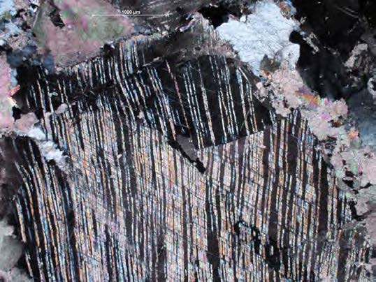
In places this limestone has been further cooked by the emplacement of basaltic lavas during periods of volcanic activity. The calcium carbonate in the limestone is re-crystallised during these metamorphic events to form marble. Pure calcium carbonate is white but there are many other minerals in the original limestone and these give the newly formed marble its characteristic streaks and patterns. Pink and cream colourations are caused by iron oxide inclusions. Impurities such as organic matter or globules of oil, are responsible for blue, grey, and black marble. Chillagoe marble is popular as a decorative stone and was used as a building stone for the new parliament house in Canberra after first being shipped to Italy and resupplied as Italian marble. Walls of Chillagoe marble can be also be seen in Cairns airport (Figure 3). The dominant minerals in limestone and marble are calcite and dolomite (Figure 4).

Quarrying is still being carried out from the flat, weathered, and smooth rock pavement. Massive cutting equipment is used to excavate from not far below the surface. The marble bedrock is cut into rows of huge regular blocks with geometric precision by vertical cuts at right angles to each other—and finally separated from the ground by a horizontal cut below (Figure 5).

The limestone is also important in the area as it was contact metamorphism of this limestone by intruding granites that caused the formation of localised gold and base metal deposits known as skarns. Discovery of these deposits in the late 1880’s allowed Chillagoe to became a beacon for copper, silver and gold miners for over 60 years.
It was John Moffat who sent out the first prospecting party into the area in 1887 and with Atherton’s help found copper in the area. From the start, Moffat tried to develop the area as a whole and Moffat’s company employed 70 miners on developmental work on deposits around Chillagoe, Redcap, and Mungana. By 1891 a smelter had been erected at Muldiva to treat the silver-lead ores and another at Calcifer in 1894 for the copper ores. Only the rich ores could be treated effectively without the necessary beneficiation so a central smelter was needed to treat lower grade ores. The Chillagoe Railways and Mines Co. Ltd was formed and in 1897 began construction on a railway from Mareeba to Chillagoe and Mungana. In 1901 the line was completed and a large copper smelting plant was opened by the company at Chillagoe. In 1903 the lead smelter was blown in (Figure 6). From then until 1914 was the most prosperous period for the district. However, much of the capital backing the companies was German and was frozen when war broke out in 1914. In 1918, the Queensland Government bought the smelters and the 1920’s saw the small miner from all districts to Cloncurry battling a corrupt government enterprise when hand-picked rich ores brought low assays. This resulted in the Royal Commission of 1930 into the key political figures involved. The smelters continued to struggle on until closure in 1943 and were sold for removal in 1950. In the 1970’s gold mining resumed and mining continues today, with Auctus Resources developing several deposits in the area.

References
http://www.mbahistsoc.org.au/locations/location-chillagoe.html
https://www.npsr.qld.gov.au/parks/chillagoe-caves/
http://static.townsvillebulletin.com.au/drive/Chillagoe.pdf
https://natureinfocus.blog/2012/06/20/rock-around-chillagoe-part-4-chillagoe-marble/


