


Rowena Duckworth, National Rock Garden Steering Committee
Published in the National Rock Garden Newsletter No. 25, May 2023
A few kilometres inland from the sparkling blue Indian Ocean, only three hour’s drive north of Perth, WA, and within the picturesque Nambung National Park, lies the Pinnacles desert where abundant weathered rock spires rise eerily out of yellow sand dunes. The Pinnacles may be as old as half a million years, but no one knows quite how and exactly when these striking natural structures were formed.
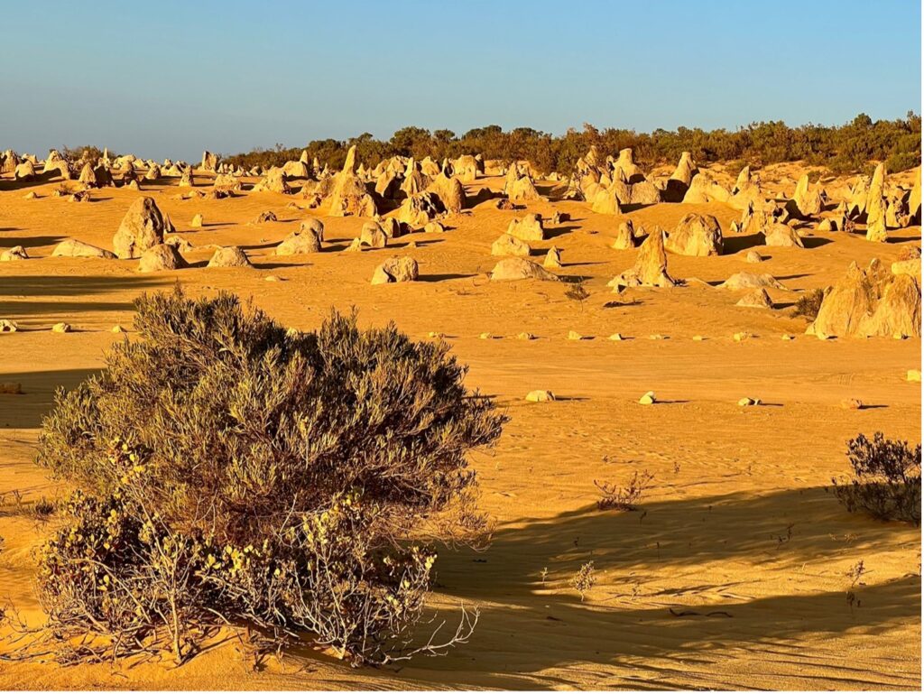
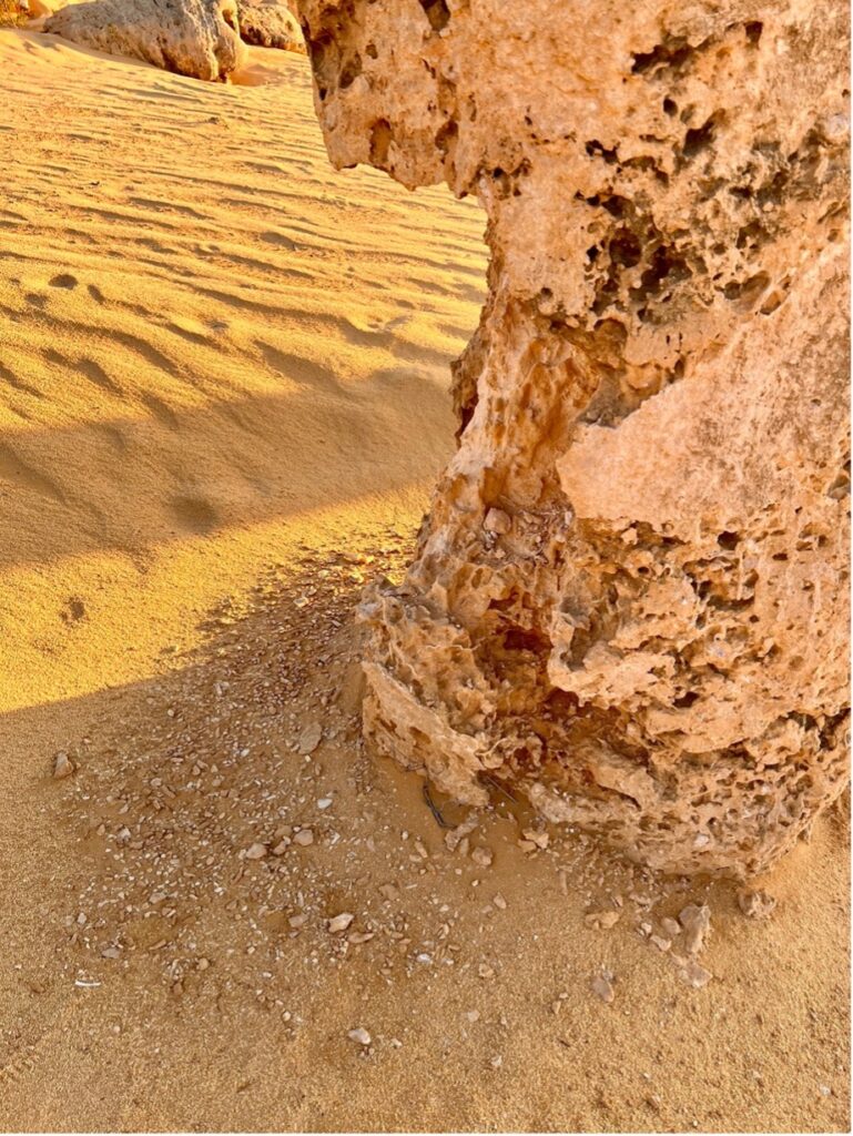
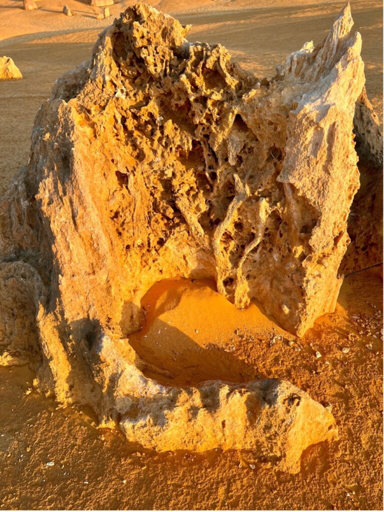
The calcarenite spires that stick out of the yellow sandy desert vary in size from several metres tall to knee-high or less, and up to 3m wide, and they resemble a petrified, paleolithic garden. They have various shapes: conical, cylindrical with rounded top, mushroom-like, and multiple peaks. Every structure seems to have its own unique, weather-beaten shape. They occur in dense fields with an average spacing between 0.5 and 5 metres, and the pinnacle tops often define a horizontal surface that decreases in direction northwards. The accumulation and erosion of the surrounding sand influence the relative height of the pinnacles. Connections can be seen between bases of certain adjoining pinnacles.
Not all the pillars are composed of the same material. Some pillars are formed of shells and algal structures, some are sandier with bedded dune sand structures, calcrete and paleosoil. Other pinnacles are composed of cemented pipe/tube fill. Several pinnacles contain all sorts of material mixed together.
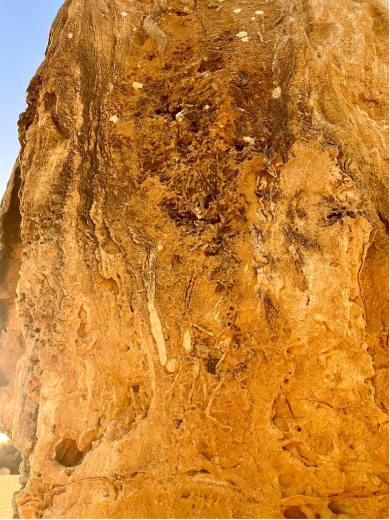
Many pinnacles are covered with a layer of carbonate cement, which can be localised and very thin (some millimetres), but it can also cover a large part of a pinnacle.
There are thousands of pillars, and all are formed of calcarenite of the Tamala Limestone. This unit extends from Shark Bay south to the southernmost point of Western Australia. It also extends in patches towards Albany along the southern coast. However, it is only here in the Nambung National Park that these pillar structures are seen. Due to ongoing erosion, transport and accumulation of sand, some pinnacles become covered while others are exhumed. Locals say oral history states that back in time the Pinnacles were totally covered in sand, and in the future, they will become buried again.
So how did the Pinnacles form? The raw material for the limestone of the Pinnacles came from seashells formed around 500,000 years ago when shallow seas covered the area. About 25,000 years ago the sea receded and these shells were broken down into lime-rich sands that were blown inland to form high mobile dunes. However, the way such raw materials formed the Pinnacles is the subject of debate and three theories have been proposed.
Due to their spectacular outcrop and easy access, the Pinnacles have attracted a good deal of scientific attention, but there is no consensus as to their origin. They have been variously interpreted as residual features resulting from widening and coalescence of solution pipes (e.g., Lowry, 1973, McNamara, 1995, Grimes, 2009, Lipar, 2009), the cemented infills of solution pipes (e.g., Playford et al., 1976, McNamara, 1983, McNamara, 1995, Grimes, 2009, Lipar, 2009, McNamara, 2009), zones of focused cementation (Grimes, 2009) or carbonate replacement of trees (Hearty and O’Leary, 2008).
The first theory states that they were formed as dissolutional remnants of the Tamala Limestone, i.e. that they formed due to a period of extensive solutional weathering (karstification). Focused solution initially formed small solutional depressions, mainly solution pipes, which were progressively enlarged over time, resulting in the Pinnacle topography. Some Pinnacles represent cemented void infills (microbialites and/or re-deposited sand), which are more resistant to erosion, but dissolution still played the final role in Pinnacle development. A second theory states that they were formed through the preservation of tree casts buried in coastal aeolianites, where roots became groundwater conduits, resulting in the precipitation of indurated (hard) calcrete. Subsequent wind erosion of the aeolianite then exposed the calcrete pillars.
A third proposal suggests that plants played an active role in the creation of the Pinnacles, based on the mechanism that formed smaller ‘root casts’ in other parts of the world. As transpiration drew water through the soil to the roots, nutrients and other dissolved minerals flowed toward the root. This mass flow process can result in the accumulation of nutrients at the surface of the root, if the nutrients arrive in quantities greater than that needed for plant growth. In coastal aeolian sands that consist of large amounts of calcium (derived from marine shells), the movement of water to the roots would drive the flow of calcium to the root surface. This calcium accumulates at high concentrations around the roots and over time is converted into a calcrete. When the roots die, the space occupied by the root is subsequently also filled with a carbonate material derived from the calcium in the former tissue of the roots, and possibly also from water leaching through the structures. Although evidence has been provided for this mechanism in the formation of root casts in South Africa, evidence is still required for its role in the formation of the Pinnacles.
Another biogenic theory proposes that as vegetation began to consolidate the dunes, humic acid accumulated from the biological material in the soil. The resulting acidic seepage water leached calcium carbonate from the upper layers of the dunes which formed a limestone cap rock some distance below the dune surface. Once the calcium carbonate has been leached from the upper levels of the dunes the seepage water began dissolving the cap rock. At first channels were dissolved through the limestone of the caprock at points of weakness like cracks, joints or holes left by decayed roots, and the limestone was redeposited further down in the dunes in stalagmite-like formations. Eventually the caprock was dissolved resulting in the limestone columns surrounded by leached quartzite sand. At some time in the recent past windblown sand covered the consolidated dunes. The vegetation was smothered, then the sand moved on leaving the previously consolidated dune unprotected from the forces of erosion. The dunes were then moved away to expose the limestone columns.
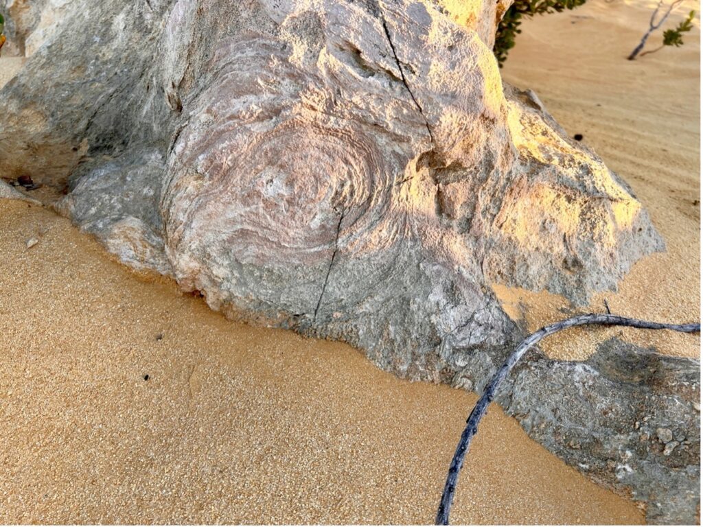
Preservation of the pinnacles means that the pinnacle material was more resistant than the surrounding material. The stronger resistance was most likely a result of greater cementation of the carbonate. A minor percentage of pinnacles are not composed entirely of a resistant material but are simply coated by it on the surface wall, and their insides are hollow spaces or composed of less resistant material that is preserved because of the protection of the resistant surface wall. A layer of carbonate cement makes the structure of the material behind it unrecognizable. The layer has most probably been formed at the time when the pinnacles were already formed but still covered with sand.
Conclusions
The Pinnacles are small towers of calcarenite up to 5 m tall and up to 2 m wide with a variety of shapes. They have formed by erosion (especially water corrosion and wind erosion) of the surrounding material to leave the more resistant parts as pinnacles. Some of the pinnacle material is a primary calcarenite and its component layers, such as bedded dune sand, calcrete and paleosoil. Their stronger resistance is probably a result of stronger focused cementation, which could be partly triggered by plant roots with chemical and mechanical processes. Rhizoliths exposed in the pinnacle material indicate the presence of plant roots in the past. Other pinnacle material is shells, algal mats and secondary cemented pipes and tubes. In the most recent paper published on these structures, Lipar and Webb (2022) stated that the pinnacles are organo-sedimentary structures with microbial cementation as the dominant process of lithification. This was based on detailed field work, morphometrical analysis of the pinnacles, thin section examination, and mineralogical, chemical and isotopic analysis of rock samples. They added that calcrete development and karstic weathering have subsequently modified the pinnacle shapes.
References
Grimes, K.G., 2006. Syngenetic karst in Australia: a review. Helictite, 39(2): 27–38. https://helictite.caves.org.au/pdf1/39.2.Grimes.pdf
Grimes, K.G., 2009. Solution pipes and pinnacles in syngenetic karst. In: Gines A., Knez M., Slabe T. & Dreybrodt W. (Eds.) Karst Rock Features: Karren Sculpturing (pp. 513–523). Ljubljana, Slovenia: Zalozba ZRC.
Hearty, P.J., 2003. Stratigraphy and timing of eolianite deposition on Rottnest Island, Western Australia. Quaternary Research, 60, 211222. https://doi.org/10.1016/S0033-5894(03)00063-2
Hearty, P.J., & O’Leary, M.J., 2008. Carbonate eolianites, quartz sands, and Quaternary sea-level cycles, Western Australia: A chronostratigraphic approach. Quaternary Geochronology, 3(1–2), 26–55. https://doi.org/10.1016/j.quageo.2007.10.001
Hearty, P.J., & O’Leary, M.J., 2010. Reply to ’Bastian L. V.’s Comment on Hearty P.J. & O’Leary M.J. 2008. Carbonate eolianites, quartz sands, and Quaternary sea-level cycles, Western Australia: A chronostratigraphic approach. Quaternary Geochronology, 3, 26–55. Quaternary Geochronology, 5(1), 78–81. https://doi.org/10.1016/j.quageo.2009.09.007
Lipar, M., 2009. Pinnacle syngenetic karst in Nambung National Park, Western Australia. Acta Carsologica, 38(1), 41–50. https://doi.org/10.3986/ac.v38i1.134
Lipar, M., & Webb, J., 2012. The formation of the pinnacles in Nambung National Park, Western Australia (abstract). 34th International Geological Congress, Brisbane, Australia. https://www.researchgate.net/publication/266081225_The_formation_of_the_pinnacles_in_Nambung_National_Park_Western_Australia
Lipar, M., & Webb, J.A., 2015. The formation of the pinnacle karst in Pleistocene aeolian calcarenites (Tamala Limestone) in southwestern Australia. Earth-Science Reviews, 140, 182–202. https://doi.org/10.1016/j.earscirev.2014.11.007
Lowry, D.C., 1973. Origin of the Pinnacles, Nambung, WA. Australian Speleological Federation Newsletter, 62, 7–8.
McNamara, K., 1983. Pinnacles. Western Australian Museum, Perth, W.A: Western Australian Museum
McNamara, K., 1995. Pinnacles (Rev. ed.). Perth, W.A: Western Australian Museum
McNamara, K., 2009. Pinnacles (Rev. ed.). Welshpool, W.A: Western Australian MuseumPlayford, P.E., Cockbain, A.E., & Low, G.H., 1976. Geology of the Perth Basin Western Australia. Geological Survey of Western Australia Bulletin, 124, 311 pp. https://library.dbca.wa.gov.au/static/Journals/080326/080326-124.pdf


