


Author: Wolfgang V. Preiss, Visiting Honorary Research Fellow, University of Adelaide and Geological Survey of South Australia
Extract from National Rock Garden Newsletter No. 19, May 2020
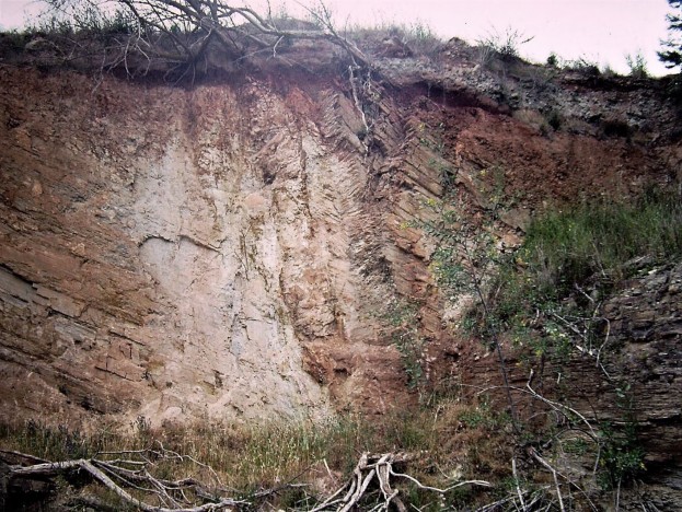
The beautiful and versatile stone known in the trade as Mintaro Slate has a long geological history and scientific significance well beyond the small Mid-North South Australian town after which it is named. The quarried rock is dark grey in colour, of fine grain size, tough and durable. It is composed of innumerable very thin parallel layers, or laminations, one millimetre or less in thickness.
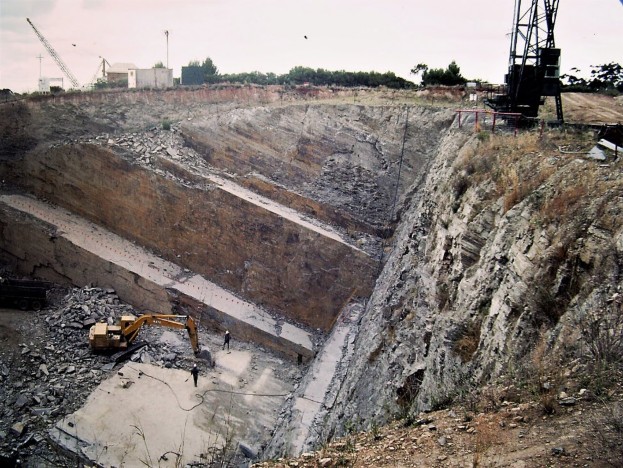
Like all mappable geological rock units (known as formations), the stone has a formal name used in scientific publications. This name was first published as ‘Mintaro Shales’ by Wilson (1952) who mapped the geology of part of the Mid-North as a post-graduate project at Adelaide University. Later the ‘s’ was dropped on the first published 1:63,360 scale geological map (Forbes, 1964) and today it is referred to as ‘Mintaro Shale’. However, the rock quarried for many industrial uses at Mintaro is actually neither a shale nor a slate. The rock type is better described as a flaggy siltstone (or flagstone), because it is predominantly composed of silt-sized particles, and displays a flaggy parting. Secondly, the rock at Mintaro lacks a cleavage which characterises slates, instead parting along the original very smooth, parallel bedding planes, which makes it ideal for paving and billiard tables. The Mintaro Shale is widespread throughout the Mid-North from just south of Kapunda to north of Orroroo. In many other places within this region it does have a cleavage, making it unsuitable for use as flagstone as the cleavage and bedding planes intersect to produce only pencil-shaped fragments.

The Mintaro Shale is part of the very thick sedimentary succession deposited during the Neoproterozoic Era in a large sedimentary basin traditionally known as the Adelaide Geosyncline, which occupied the region of the present Mount Lofty Ranges, Mid-North and Flinders Ranges. The sedimentary rocks were laid down in a variety of marine and terrestrial environments. The Mintaro Shale was deposited as silt in a marine environment, probably in quiet, relatively deep water, perhaps at 100-200 m depth, near the outer limit of an ancient continental shelf. The sediment was derived from the weathering and erosion of older landmasses neighbouring the basin. After deposition, the sediment was compressed by the weight of overlying sediment, dewatered, and lithified to form a hard siltstone.
The most recent geological mapping of the Mintaro area can be accessed through SARIG on the South Australian Department for Energy and Mining’s website.
The exact age of deposition cannot be specified at present, but can only be constrained by the ages of dated rocks above and below in the stratigraphic succession. About three kilometres below the Mintaro Shale lies the Skillogalee Dolomite (also named by Wilson, 1952) which, in the nearby Burra Copper Mine, contains volcaniclastic and intrusive rocks dated at about 790 Ma (Preiss et al., 2009). About one kilometre above the Mintaro Shale is the Appila Tillite (Thomson et al., 1964). The latter formation is part of glacial sediments that resulted from a widespread ancient glaciation and are found throughout the Flinders and Mount Lofty Ranges. The waning stage of this glaciation has been dated at 663 Ma on a thin volcanic ash bed in the northern Flinders Ranges (Cox et al., 2018).
Long after deposition, between about 510 and 500 Ma, the whole sedimentary succession was folded and faulted in a mountain-building event known as the Delamerian Orogeny. During this event, many of the finer grained sedimentary rocks were cleaved by the compressive stresses. Mintaro was, however, at the southern closure of an open, large-scale syncline in an area of little strain in the rocks, and so they have escaped being cleaved and folded on a small scale. This means that the beds have remained planar, with parallel partings, although they are inclined at a low to moderate angle to the northwest. These features can be clearly seen in the quarry.
The Mintaro Shale has geoscientific significance beside its many practical applications. Two additional features are of special interest, though they have not necessarily been welcomed by the quarry operators: sand dykes and pebbles.
Sand dykes varying in width from a few centimetres to nearly one metre have been observed in some of the quarry workings, as well in other outcrops of the Mintaro Shale in the Mid-North. These originated as deep, open fissures that developed once the siltstone was consolidated, though not necessarily as highly lithified as it is now. Sand probably flowed into these fissures from above when sand was carried out into the basin by marine currents after silt deposition finished and the fissures opened. Alternatively, fluidised sand could have been injected from below. Either way, the sand sources are enigmatic as the closest sandstone units occur hundreds of metres above and below the Mintaro Shale.
Over more than a century of mining, the quarry operators have occasionally found rare pebbles encased in the siltstone. These were first recorded by Government Geologist L.K. Ward, who suggested that they had been ice-borne (in Jack, 1923, p. 28). Pebbles range from one to ten centimetres in diameter, and are of various rock types, including sandstone, quartzite and limestone (Preiss, 1987). In much younger sediments, stones can be carried out to sea by floating logs but these rocks are hundreds of millions of years older than the earliest plants. It is difficult to envisage a mode of transport other than by floating ice for isolated ‘lonestones’ into such distal sedimentary environments, which are normally reached by only fine-grained sediments.
The Mintaro Shale is substantially older than the well-known glaciation represented by the Appila Tillite, being separated from it by two additional formations and a major unconformity, but it is not known just how much older. Interestingly, Mawson and Sprigg (1950) suggested that rocks of the Belair Subgroup in the Adelaide Hills, which includes equivalents of the Mintaro Shale, had glacial affinities. So far it has not been possible to date the Mintaro Shale directly. Some Neoproterozoic glacial deposits in other parts of the world have been dated as older than the South Australian tillites, for example 717 Ma in Canada (Macdonald et al., 2018). If it could be shown that the pebbles in the Mintaro Shale relate to one of these older glacial periods it would greatly enhance the international significance of these rocks.
References
Cox, G., Isakson, V., Hoffman, P., Gernon, T., Schmitz, M., Shahin, S., Collins, A., Preiss, W., Blades, M., Mitchell, R. and Nordsvan, A., 2018. South Australian U-Pb zircon (CA-ID-TIMS) age supports globally synchronous Sturtian deglaciation. Precambrian Research, 315:257-263.
Forbes, B.G., 1964. Clare, South Australia. 1:63,360 Geological Atlas Series Map. Geological Survey of South Australia, Adelaide.
Jack, R.L., 1923. The building stones of South Australia. Bulletin of the Geological Survey of South Australia, 10.
Macdonald, F.A., Schmitz, M.D., Strauss, J.V., Halverson, G.P., Gibson, T.M., Eyster, A., Cox, G., Mamrol, P. and Crowley, J.L., 2018. Cryogenian of Yukon. Precambrian Research, 319:114-143.
Mawson, D. and Sprigg, R.C., 1950. Subdivision of the Adelaide System. Australian Journal of Science, 13, 69 –72
Preiss, W.V. (compiler), 1987. The Adelaide Geosyncline. Late Proterozoic stratigraphy, sedimentation, palaeontology and tectonics. Bulletin of the Geological Survey of South Australia, 53.
Preiss, W.V., Drexel, J.F. and Reid, A.J., 2009. Definition and age of the Kooringa Member of the Skillogalee Dolomite: host for Neoproterozoic (c. 790 Ma) porphyry- related copper mineralisation at Burra. MESA Journal, 55:19- 33.
Thomson, B.P., Coats, R.P., Mirams, R.C., Forbes, B.G., Dalgarno, C.R. and Johnson, J.H., 1964. Precambrian rock units in the Adelaide Geosyncline: a new subdivision. Quarterly Geological Notes, Geological Survey of South Australia, 9:1-19.
Wilson, A.F., 1952. The Adelaide System as developed in the Riverton-Clare region, northern Mount Lofty Ranges, South Australia. Transactions of the Royal Society of South Australia, 75:131-149.
Glossary
| Bedding | Primary layering in sedimentary rocks. |
| Claystone | A sedimentary rock composed predominantly of clay-sized particles (less than 0.0039 mm in diameter). |
| Cleavage | The tendency of a rock to split along aligned very fine-grained platy minerals, typical of slate. |
| Formation | A geological rock unit which can be traced and mapped over a certain area. It may contain one or several related rock types. |
| Lithification | The process of hardening of soft sediment into hard sedimentary rock by combinations of compaction, dewatering, cementation and recrystallisation. |
| Lonestone | Isolated pebble or cobble embedded within fine-grained sediment. Lonestones that can be demonstrated to have dropped into soft sediment from above are known as ‘dropstones’. |
| Ma | Million years before present. |
| Neoproterozoic Era | Geological era between 1000 Ma and 541 Ma. |
| Sand dykes | Fissures in sedimentary rock infilled with sand. |
| Shale | Fissile claystone parting on thinly spaced bedding planes. |
| Silt | Sedimentary particles between 0.0039 and 0.063 mm in diameter. |
| Siltstone | Sedimentary rock composed predominantly of silt-sized particles. |
| Slate | A low-grade metamorphic rock with strong cleavage. |
| Stratigraphy | The scientific study of sedimentary strata and their relationships. |
| Syncline | A U-shaped fold in layered rocks with the younger layers on the inside and older on the outside. |
| Tillite | A poorly bedded rock composed of a wide range of grain sizes from clay, silt, sand and pebbles to boulders interpreted to have been deposited by glaciers. |
| Unconformity | A gap in the sedimentary record during which the underlying strata were eroded before deposition of the overlying beds. |
| Volcaniclastic | Sediment composed of contemporaneous volcanic fragments. |


