


Authors: Mike Smith, Director, National Rock Garden, and Sarah Buckerfield, Geophysicist, Geoscience Australia
Extract from National Rock Garden Newsletter No. 12, March 2016
The National Rock Garden (NRG) will be a permanent facility in a landscaped environment on a five hectare site. The current NRG Masterplan indicates that rocks will be exhibited in a variety of layouts including the excavation of a flat area in the southern portion where a gallery of very large rock specimens will be placed, adjacent to an elevated amphitheatre.
In addition, a series of gorges are planned to be excavated in the central portion of the area and lined with rocks laid out to demonstrate a wide range of geological structures. A series of rock clusters will be dispersed along pathways of the geological walk. This article describes a geotechnical study aimed at locating any near-surface occurrences of hard rock which could impact on future plans to excavate into the gently sloping face of the NRG site.
The NRG site occurs on the Coppins Crossing 1:10,000 geological map sheet. There is no rock exposure on the site, butthe basement rocks are believed to be mid-Silurian Mount Painter Volcanics, which reportedly includes dacite, rhyodacite, shale, siltstone, ashstone and limestone. The lack of rock outcrop means that the exact lithology and the depth to fresh rock are not known. It is likely that small south- flowing drainage lines existed on the site flowing down from the elevated terrain now occupied by the National Arboretum. Thus, it is speculated that there could be buried ridges and gullies that lie concealed beneath the current land surface. Accurate knowledge of the location of basement ridges, as well as the depths to fresh rock, is important to assist the design of the proposed excavation work.
In order to map the basement topography, below the area where excavation is expected to be undertaken, a geotechnical study has been planned for the NRG site. The NRG Steering Committee is extremely grateful to the geophysical staff from Geoscience Australia who have agreed to undertake these measurements. The geotechnical work has so far involved ground penetrating radar (GPR) and passive seismic studies.
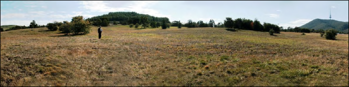
A comprehensive risk analysis for the geotechnical survey has been completed. The proposed work site presents no obvious hazards to the geotechnical survey team, as the area is lightly vegetated with grasses and small trees, and has a very mild slope. There are no pits, potholes, fences or power cables. In addition, the proposed survey methods present a very low risk of injury to the operators. The site is adjacent to a public area which includes a cycling path, and members of the Steering Committee have been present to explain the purpose of the work to any inquisitive onlookers.
Ground penetrating radar and passive seismic work have been carried out and the results are being processed and interpreted. Further measurements may be taken if there are important areas lacking information.
Ground penetrating radar is a non-destructive, very low impact technique used in many applications studying depths near the ground surface. Applications include rock and soil mapping, groundwater mapping, and detecting pipes, fractures, or buried objects. The method is probably best known for its use in the archaeological investigations undertaken in the BBC television series, ‘Time Team’. High frequency radio waves are emitted into the ground and are reflected off boundaries between rocks, soil and concrete, and absorbed to different degrees by different soil types (e.g. clay/sand). The returning reflected waves are detected and recorded and can be used to map the subsurface.
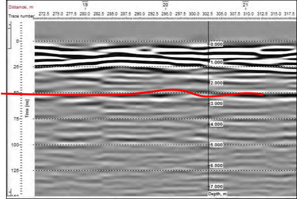
In late May 2015, the NRG site was covered by a 50m grid oriented NE-SW and NW- SE and these GPR measurements are currently being processed and evaluated. The presence of clays limits the technique but we believe that we have obtained useful information about the overburden down to about three metres depth, and hopeful that we have picked up the weathered basement in some places. The following profile is an example of where we believe we have detected weathered basement. Strongly reflecting layers are evident in the top of the section (surface to 1.5 metres) which would derive from layered sediments in the overburden. Over the depth range 2.5 to 4 metres, there is a weak reflector that could represent the weathered bedrock. In this example (see image below) the reflector is located at 2.5 to 3m depth, with the interpreted pick shown in red.
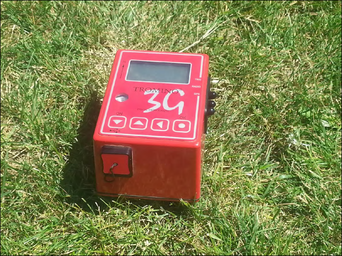
Passive seismic is a non-destructive, very low impact technique used to study the composition of rocks and soil at a range of depths beneath the ground surface. Passive seismic techniques utilise the sound waves from ambient sources such as traffic and machinery, distinguishing it from the refraction seismic method which uses sound waves created specifically for the survey operation.
The instrument (see image below) is placed on the ground surface to measure seismic waves as they arrive from a wide range of natural and artificial sources. This information is used to estimate the speed of seismic waves through soil and rocks beneath the surface, which can be used to infer what types of soils or rocks are found in that location. This cheap and relatively simple technique has proven highly successful not only in shallow engineering applications but also in imaging rocks up to hundreds of metres below the surface.
The results from the National Rock Garden site are of high quality and are currently undergoing analysis and interpretation. A three component sensor records horizontal and vertical motion, in the northerly, easterly, and vertical directions. The ratio of the horizontal to vertical components is calculated and graphed as a function of frequency. The frequency at which the horizontal to vertical ratio is at a maximum changes depending on the depth at which a distinct velocity contrast occurs.
The first interpretation results confirm the presence of a strong change from low velocity material at the surface to moderate velocity material at between 1 to 3 metres depth at various locations, probably the same feature as shown in the ground penetrating radar data. Interpretation is continuing.
Additional results of the various geotechnical measurements will be reported in a subsequent issue of the NRG Newsletter.


