


Steve Hill, Chief Scientist, Geoscience Australia
Published in the National Rock Garden Newsletter No. 26, December 2023
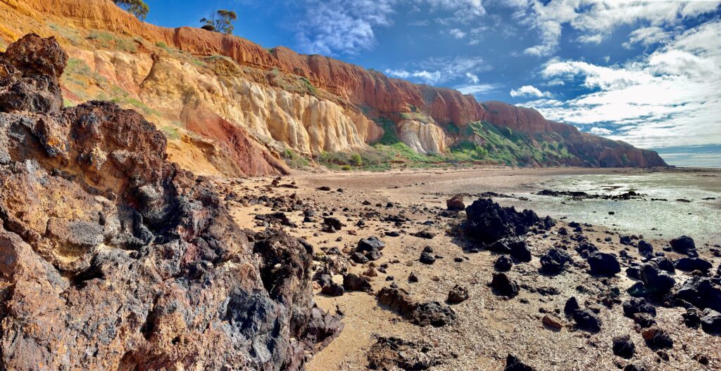
If you want to spend a day at the beach but also amongst part of the Earth’s most metal endowed geology, then a trip to Pine Point on the Yorke Peninsula is a day well spent. Nowhere else is such a complete section of mineralised geology of the iconic Olympic Copper-Gold Province (which hosts the Olympic Dam, Prominent Hill, Carrapateena and Moonta-Wallaroo deposits) of the eastern Gawler Craton so well exposed in the landscape—in this case, along a quiet stretch of coastline within a two- hour drive from Adelaide. The coastal section, extending several kilometres northwards from Pine Point, includes uplifted and eroded sections within the Pine Point Fault Zone featuring Iron-Oxide-Copper-Gold (IOCG) mineralised Olympic Province geology, as well as some of the diversity of the Cambrian to present day basin cover that otherwise conceals this incredibly metal-endowed part of the Earth’s crust.
A good starting point for exploring this area’s geology is from the northern extent of the mostly beach shack village of Pine Point where Main St / Esplanade ends… that’s assuming that you don’t include stop-overs at the bakeries of Port Wakefield and Ardrossan as invariably the real ‘starting point’ for exploring the geology of this part of the world! (Maybe not a Kitchener bun, but you will soon be able to walk off baked goods consumption by looking at geology!) From there it is up to you how far northwards you walk. You can either turn back and retrace your steps or else continue onwards if you have organised a car-shuffle for one of the coastal access points either near Muloowurtie Point / Harts Mine or further north at Rogues Point. The best time to do this walk is at low-tide, and please be careful at the base of some of the unstable cliff sections.
The first part of the walk northwards includes interesting exposures of sedimentary rocks of the Stansbury Basin (Cambrian, Yurunga Formation) where there are some folds in red-beds and quartzites as well as some fanglomerates that are likely to have been deposited along the paleo-scarp of the Pine Point Fault. The early part of the walk provides interesting juxtaposition of the younger Cambrian sequence mostly along the shore-platform and through the beach, with the older more weathered Proterozoic Gawler Craton rocks exposed in the faulted coastal bluffs. A good guide for finding exposures of the mineralised Proterozoic sequence is to look for higher concentrations of magnetite in the beach sands (a magnet can be helpful here) and trace these back to the source at the coastal bluff or gully.

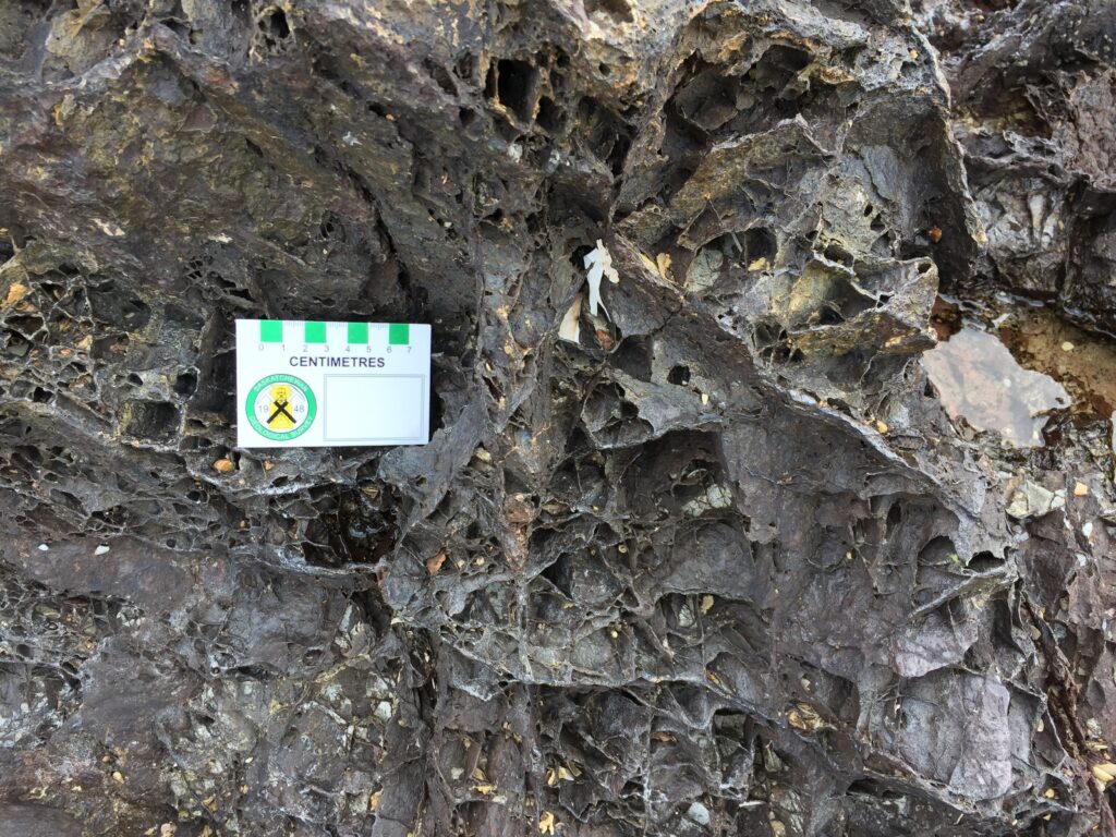
After about a kilometre, the coast enters a small headland that shelters on its northern side, a small cove with spectacular cliffs composed of bright, white kaolinized granite overlain with mostly red-brown and yellow-brown sediments of the Cenozoic St Vincent Basin. This place is known as White Clay Bay, and you can easily spend quite a bit of time examining the geology here. Near the headland at the southern end of the bay are jagged, dark exposures of weathered skarn-type IOCG mineralisation, associated with amphibole-rich, calcsilicate alteration along steeply dipping structures. The exposures have prominent ‘box-work’ textures formed by iron oxides replacing the outlines of amphiboles, sulphides and the intense fracturing in the rock. This mineralisation is closely associated with the Dead Horse Bay uranium prospect (Hiern, 1957) and the Hillside IOCG deposit (which occurs beneath the farm paddocks immediately inland of these coastal exposures). Within the bay itself, the prominent, white kaolinized granite is part of the Mesoproterozoic, Arthurton Granite that has been both hydrothermally altered and weathered. These clays once supported a small mining operation, where loading barges could access the coastal exposures (Crawford, 1957; Keeling et al., 2000).
The overlying Cenozoic St Vincent Basin sediments are mostly part of the Eocene shallow marine, estuarine and beach deposits (Stuart, 1970). Towards the upper parts of the sequence there are remnants of Oligocene-Miocene Port Vincent Limestone and sections through Quaternary sediments, mostly including aeolian dunes with paleosols and calcretes. Interestingly there are two types of calcrete in these sections: 1. friable, pedogenic types that have formed in the soils of the dune sequence; and, 2. typically deeper and harder pedogenic calcretes that have formed from the weathering of the Port Vincent Limestone. Each of these two calcrete types have very different geochemical properties associated with their different evolution.
From here it is spectacular to continue northwards where the coastal section also includes further exposures of faulting along the Pine Point Fault Zone, Paleoproterozoic mafic rocks, intense alteration zones, as well as green, malachite-rich exposures of copper mineralisation, such as at Harts Mine (Drexel, 1979). How much further north you proceed is really a question of your willingness, the tides and how you are managing either a walk back to Pine Point or a car drop-off / pick-up further north (and perhaps whether you did have a Kitchener bun at the bakery!).
There are plenty of other great nearby sites to view geology on the northeastern Yorke Peninsula That could add to your day. A few other sites include the cliffs at Ardrossan Jetty (ferruginised Cainozoic sediments), Ardrossan Lookout (just off Yorke Highway on southern margins of Ardrossan township), Rocky (Quartoo) Point (St Vincent Basin section with silcretes), Port Vincent (Permian erratics and sediments).
Acknowledgements
Thanks to Geoff Lowe and Steve Olsen from when they worked at Rex Minerals and sparked interest in the potential for regolith geology study in this area, as well as Rex Minerals geologists including Marc Twining, Rohan Worland, and Lachlan Cole. The author has run numerous group field trips to this site for Deep Exploration Technologies Cooperative Research Centre (DET CRC), University of Adelaide, Geological Survey of South Australia, Australian Regolith Geoscientists Alliance of the Geological Society of Australia, and the National Exploration School (NExUS) and benefitted enormously from discussions on all of these trips. For generations the Narrunga people have had a close connection to this amazing landscape, please be mindful and respectful of this when visiting the area.
References
Crawford, A.R., 1957. Ardrossan (Pine Point) clay deposit. South Australia Mining Review, 104, 22–23. https://sarigbasis.pir.sa.gov.au/WebtopEw/ws/samref/sarig1/wci/Record;jsessionid=EFAE22D63F3838B557ECA8 C602EBCCA4
Drexel, J.F., 1979. Mineral occurrences south of Ardrossan – Hillside, Phillips and Harts Mines. SA Dept Mines Report Book 79/77. https://sarigbasis.pir.sa.gov.au/WebtopEw/ws/samref/sarig1/wci/Record?w=catno=1007572&m=1&rpp=1
Hiern, M.N., 1957. Dead Horse Bay uranium prospect, Section 42B HD Muloowurtie CO Fergusson. SA Dept Mines Report Book 45/18. https://sarigbasis.pir.sa.gov.au/WebtopEw/ws/samref/sarig1/wci/Record?r=0&m=1&w=catno=2001325
Keeling, J., Wright, M., Fitzpatrick, R. & Hartley, K., 2000. Field Guide for Post-Conference Tour, 17th Biennial Conference Australian Clay Minerals Society Inc. https://sarigbasis.pir.sa.gov.au/WebtopEw/ws/samref/sarig1/wci/Record?r=0&m=1&w=catno=2021613
Stuart, W.J., 1970. The Cainozoic stratigraphy of the eastern coastal area of the Yorke Peninsula, South Australia. Royal Society of South Australia Transactions, 94, 151–178. https://www.biodiversitylibrary.org/page/41070919


