


Brad Pillans, Director, National Rock Garden
Extract from National Rock Garden Newsletter No. 23, May 2022
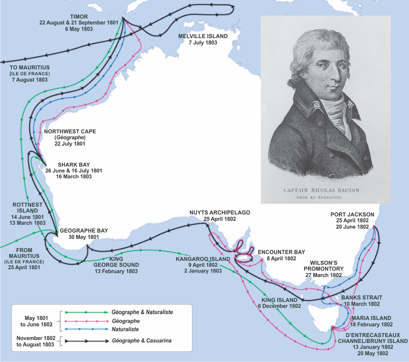
The 1801–1803 French expedition of discovery, led by Captain Nicholas Baudin, explored large parts of Australia’s western and southern coasts (Fig. 1). The expedition, comprised of two ships (Géographe and Naturaliste), sailed from Le Havre in October 1800, having been approved by none other than Napoleon Bonaparte himself, then First Consul of France. According to the list of crew members, there were 22 ‘Naturalists’ and ‘Savants’ on board, 14 of whom had formal scientific qualifications. Two of the scientists, Louis Depuch and Joseph Charles Bailly, were trained mineralogists—we would call them geologists, today—and they were the first professionally educated geologists to visit Australia (Mayer 2009).
Sadly, Depuch did not survive the voyage (neither did Baudin) and it was left to Bailly and the expedition zoologist, François Péron, to report the results of the geological discoveries, on return to France. In 1806, Péron was asked by the French Government to write the official history of the voyage, but he died in 1810, having only completed the first volume. Naval Officer Louis Freycinet was then asked to finish the task and completed the work in 1816.
At the time, the science of geology was in its infancy, but Depuch and Bailly made many valuable observations of rocks in Australia. One of the rock types that they studied, was Tasmanian dolerite, the rock we chose as the Tasmanian state rock in our NRG Federation Rocks display. They wondered whether it might be a type of granite, then settled on it being a type of basalt, but neither suggestion turned out to be correct. We now know that the dolerite was intruded at shallower crustal levels than granite, but it is not a volcanic rock (like basalt) because it did not reach the surface.
One of the other rock types that they studied, was what we now know as Tamala Limestone, in Western Australia, which is a type of limestone formed by cementation of coastal dune and beach deposits (see the article by Andy Spate, in this issue). I would be very pleased if we could obtain a block of Tamala Limestone for display in the NRG—to celebrate the ‘French Connection’.
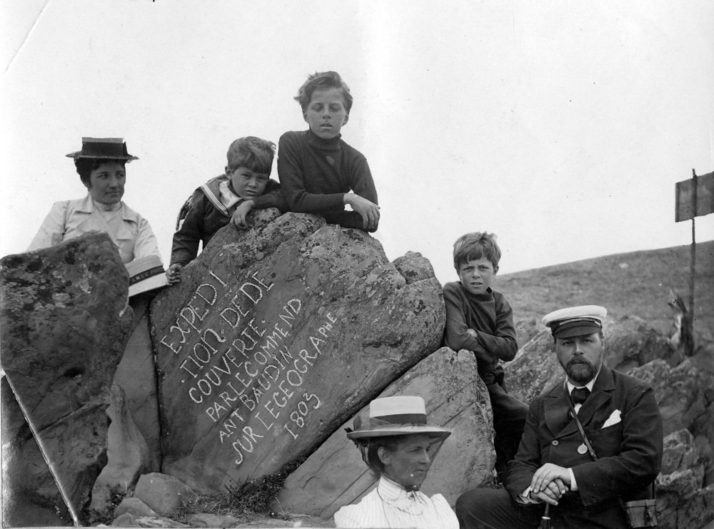
In 1803, the Baudin expedition also spent time around Kangaroo Island, where one of the crew carved the following inscription on a rock near present-day Hog Bay: ‘Expedition de decourverte par le commandant Baudin sur le Geographe 1803.’ (Expedition of discovery by Captain Baudin of the Geographe 1803.)
Hallam Tennyson, son of the famous English poet, Lord Alfred Tennyson, visited the spot with his family one hundred years later (image below), at the end of his term as governor of South Australia. At the time (1903), the state was celebrating the centenary of the meeting of Baudin and Matthew Flinders at Encounter Bay. The inscribed rock, now known as Frenchman’s Rock, was subsequently removed from the site, for safe keeping, and is now displayed in a glass case at the Kangaroo Island Visitor Centre in Penneshaw. A replica rock has been placed at the original site.
In mid-1902, the first Governor General of Australia, Lord Hopetoun, resigned, and Tennyson, as the senior state governor, became Administrator of the Government (effectively, acting Governor General) from 17 July 1902 to 9 January 1903. He then served a one-year term as Governor General until he departed from Australia in January 1904. He retired to the Isle of White as 2nd Baron Tennyson, having inherited the title on the death of his father, Alfred (1st Baron Tennyson), in 1892.
References
Mayer, W., 2009. The geological work of the Baudin Expedition in Australia (1801-1803): the mineralogists, the discoveries and the legacy. Earth Science History, 28: 293-324. Available at https://openresearch-repository.anu.edu.au/bitstream/1885/20167/2/01_Mayer_The_Geological_Work_of_the_2009.pdf
Sankey, M., 2011. The cartography of the Baudin expedition: Louis de Freycinet’s map of New Holland. In: Gerritson, R., King, R., Eliason, A. (Editors), The Freycinet Map of 1811: Proceedings of the Symposium Commemorating the 200th Anniversary of the Publication of the First Map of Australia. Australasian Hydrographic Society, Canberra, pp. 2-19. Available online.


